


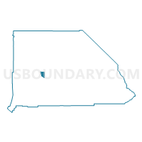
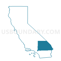
Voting District 11190, San Bernardino County, California
About
Outline

Summary
| Unique Area Identifier | 539688 |
| Name | Voting District 11190 |
| County | San Bernardino County |
| State | California |
| Area (square miles) | 39.03 |
| Land Area (square miles) | 39.03 |
| Water Area (square miles) | 0.00 |
| % of Land Area | 100.00 |
| % of Water Area | 0.00 |
| Latitude of the Internal Point | 34.77926900 |
| Longtitude of the Internal Point | -116.78976240 |
Maps

Graphs
Select a template below for downloading or customizing gragh for Voting District 11190, San Bernardino County, California


Neighbors
Neighoring Voting District (by Name) Neighboring Voting District on the Map
- Voting District 11175, San Bernardino County, CA
- Voting District 11195, San Bernardino County, CA
- Voting District 11295, San Bernardino County, CA
- Voting District 11350, San Bernardino County, CA
- Voting District 32330, San Bernardino County, CA
Top 10 Neighboring County Subdivision (by Population) Neighboring County Subdivision on the Map
- Victorville-Hesperia CCD, San Bernardino County, CA (370,441)
- Barstow CCD, San Bernardino County, CA (41,257)
- Newberry Springs-Baker CCD, San Bernardino County, CA (12,696)
Top 10 Neighboring Unified School District (by Population) Neighboring Unified School District on the Map
Top 10 Neighboring State Legislative District Lower Chamber (by Population) Neighboring State Legislative District Lower Chamber on the Map
Top 10 Neighboring State Legislative District Upper Chamber (by Population) Neighboring State Legislative District Upper Chamber on the Map
Top 10 Neighboring 111th Congressional District (by Population) Neighboring 111th Congressional District on the Map
Top 10 Neighboring Census Tract (by Population) Neighboring Census Tract on the Map
- Census Tract 121.04, San Bernardino County, CA (5,110)
- Census Tract 103, San Bernardino County, CA (3,846)